

An aerial view of Mount St. Helens during one of my flights from Seattle to Portland in 2018
Photos by Cheryl Landes, except as noted
Today is the 40th anniversary of the eruption of Mount St. Helens. On the day the mountain erupted, I was approaching the end of my freshman year at Eastern Oregon State College (now Eastern Oregon University) in La Grande.

A view of Mount St. Helens two weeks before it erupted from the Pittock Mansion in Portland, Oregon (photo credit: The Oregonian)
The mountain spewed 500 million tons of ash into the air, which covered Washington, Idaho, Montana, and parts of northern Oregon. The mudflow from the eruption destroyed 200 square miles of forest and collapsed the mountain from 9,677 feet to 8,365 feet. Northwesterners heard the explosion more than 150 miles away.
Media reports stated that the ash traveled as far as the Atlantic Ocean and affected air travel. If the ash entered a plane’s engines, it could cause serious damage.
La Grande is located in the northeastern corner of Oregon in the Grande Ronde Valley, 270 miles southeast of Mount St. Helens. The Grande Ronde Valley is surrounded by mountains. La Grande, which had a population of 12,500 back then, is at the southern end of the valley.

A view of Mount Emily in the Blue Mountains and the Grande Ronde Valley from La Grande, Oregon, in 2016
Although the valley was on the southern fringe of Mount St. Helen’s ash path, the effects of the eruption were dramatic.
When the mountain blew on the morning of Sunday, May 18, 1980, I didn’t hear it, but it was clear something happened. Our usual sunny, pleasant spring weather changed suddenly. We didn’t experience the complete darkness like cities in the direct ash path, such as Spokane 250 miles north of us, but the eruption triggered two weeks of cloudy, rainy days. This is unusual for La Grande, especially in the spring. The Grande Ronde Valley’s climate is mostly dry year-round. The annual precipitation there is 18 inches.
 The eruption of Mount St. Helens on May 18, 1980 (photo credit: KOIN-TV in Portland, Oregon)
The air was gritty. I don’t remember seeing much ash on the ground, maybe because of the constant rain, but it was in the air. My main modes of transportation were riding my 10-speed Montgomery Ward bicycle and walking, so by the time I arrived anywhere, my skin felt gritty from the ash and I saw wet ash in my bicycle chain and tires. People I knew who had cars said they couldn’t use their windshield wipers, because the ash etched grooves in their windshields.
The weekend after the eruption, I traveled to Moscow, Idaho, with a youth group from the college. Moscow, located 182 miles northeast of La Grande and 79 miles southeast of Spokane, was also in the direct ash path.
The camp where we stayed felt eerie with the thick layer of ash everywhere. The ground, buildings, even the trees were covered in a layer of ash from six to 12 inches thick. It was as if a powder gray snowstorm passed through overnight and the views were from black-and-white photos.
It was also unusually quiet. No birds sang. I didn’t see any birds or animals, either. I wondered where they were.
The sun shined in Moscow that weekend, and the air was humid and still. The daytime temperatures were in the 90s, higher than normal for western Idaho in May. Humid days are also unusual there.
Because there was so much ash, it floated in the air. When I walked outside, the ash stuck to my skin, forming a thin layer of dark, gritty mud on my face, arms, and legs.
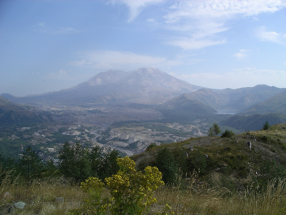
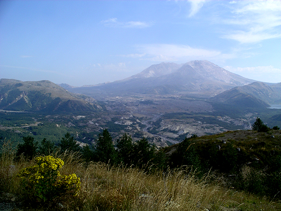
In September 2006, I returned to Mount St. Helens for the first time since before the eruption and was amazed by the rejuvenation happening in the blast zone. Although much evidence remained of the destruction, flowers, trees, and other plants grew from the ash. I saw some ground squirrels flitting around at some of the viewpoints where I stopped. The scenery was still beautiful but different. It was a testimony of renewal and still is, every time I visit.
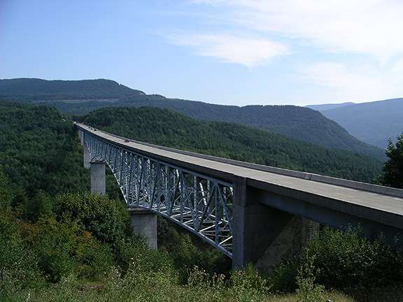
Here are some photos of my first trip back to Mount St. Helens on that hazy day in 2006. The first picture below is the Hoffstadt Creek Bridge on Washington State Highway 504, the road that connects Interstate 5 to the Johnston Creek Observatory in the Mount St. Helens National Monument. The bridge marks the start of the blast zone.


If you’d like to learn more about the Mount St. Helens eruption and renewal, here’s a great 58-minute documentary produced by public TV station KSPS in Spokane in 2015.
Here are more photos of the eruption and the aftermath from KOIN 6 TV in Portland:
Photos: The 1980 Mt. St. Helens Eruption

An aerial view of Mount St. Helens during one of my flights from Seattle to Portland in December 2017.
Mount St. Helens is still an active volcano. The dome continues to build in the crater, and smaller eruptions have occurred since 1980. Geologists believe another large eruption will happen, but they aren’t sure when.
See pictures of Mount Saint Helens in 2020 in my armchair photo tour, “A trip to Mount St. Helens 40 years post-eruption“.

2 thoughts on “Armchair photo tours: Mount St. Helens”